The Cropping tab (pictured below) allows you to crop the selected overlay(s) to a particular boundary, including support for automatically removing the collars from USGS DRG topographic maps.
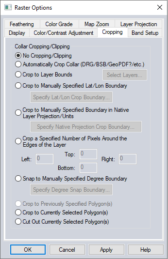
Automatically Crop Collar (DRG/BSB/etc.)
This option is used to automatically remove the collar from loaded raster data if the collar is in a recognized format. Most frequently it is used to removes the white border around a DRG, the small black collar around a 3.75 minute DOQQ, or the map collar around a BSB marine chart. This allows seamlessly viewing a collection of adjacent BSB, DRG, or DOQQ files.
Crop to Layer Bounds
This option will use the layer bounds of one or more loaded layer(s) in the workspace to crop the selected layer(s). Use the Select Layers button to select the layer(s) to use as the crop boundary.
Crop to Manually Specified Lat/Lon Boundary
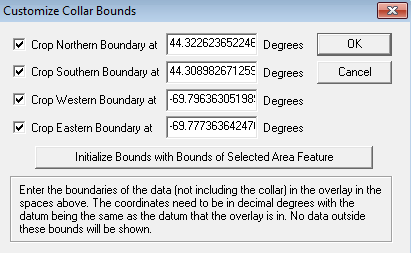
This option allows specifying
a lat/lon boundary (in the native datum of the selected overlay) to crop
the overlay to. When selected, this option will display the Customize
Collar Bounds dialog (pictured below) to allow specifying the bounds
to crop to.
Crop to Manually Specified Boundary in Native Layer Coordinate System/Units
The option allows specifying a crop boundary in the native units of the selected overlay. When selected, this option will display the Customize Collar Bounds dialog (pictured above) to allow specifying the bounds to crop to.
Crop a Specified Number of Pixels Around the Edges of the Layer
This option allows specifying a number of pixels to crop of each edge of the selected overlay(s).
Snap to Manually Specified Degree Boundary
This option allows specifying that the collar for the selected overlay will be on some degree boundary, like an even degree, of 0.5 degrees, etc. Allowing the user to setup cropping for a collection of maps that are all similarly aligned.
Crop to Previously Selected Polygon(s)
The option allows cropping to the defined crop polygon(s) (area) previously applied to the selected layer(s) by using the Crop to Currently Selected Polygon option.
Note: To recreate the polygon from a previously cropped layer, choose the tool Save Feather and Crop Polygons to Layer from, the Favorites List in Favorites Toolbar and use the  run button to create the polygon layer.
Crop to Currently Selected Polygon(s)
This option allows specifying the area to crop by cropping the selected layer(s) to any area feature(s) currently selected with either the Feature Info or Digitizer Tools.
Cut Out Currently Selected Polygon(s)
This option allows cropping out the currently selected polygons from the raster layer. This will create holes in the raster layer where the polygons are.