LandXML
Global Mapper supports import and export of LandXML files.
The supported feature types are:
The vertical unit is an option attribute in the LandXML format. When no unit is specified, Global Mapper will default to loading the vertical as Meters. The unit interpretation can be controlled from the Layer Options Elevations Tab (Vector Data).
Export LandXML
The LandXML export is available from the menu File > Export > Export Vector/Lidar Format... and File > Export > Export Elevation Grid Format...
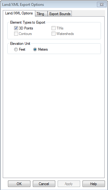
Element Types to Export
Specify the types of features to include in the export. The default selection will be made automatically based on available data.
Contours are line features that have one of the Contour feature types specified.
Watersheds are area features that have Watershed identified as the feature type.
TINs are TIN vector features or gridded elevation/terrain layers. Exporting a terrain surface to LandXML format will generate and export a triangulated network of vector features by sampling the terrain layer(s) at the specified sample spacing.
Elevation Unit
Specify the output vertical unit as feet or meters.
Sample Spacing
When exporting a terrain surface the sample spacing allows the user to set the spacing used to sample the terrain data when generating the exported TIN. The default value is the average of the grid spacings of all the currently loaded elevation overlays.
Interpolate to Fill Small Gaps in Data
Any small areas with missing data will be filled by interpolating the surrounding valid data using an IDW method. This is useful for filling gaps between adjacent tiles or small holes in elevation data.
Save Projection Information to File
Unchecking this option will result in an output file without internal projection information.
Tiling Panel
Export Bounds
Format Updates
Below is a summary of recent updates to LandXML format support.
| Version | Description |
|---|---|
| 22.0 | Added support for exporting terrain data to Land/XML as a TIN. [Item #GM-9472] |
| 22.0 | Added ability to export TINs, Points, and Contours to Land/XML via a script.[Item #GM-7759] |
| 19.0 | Modified LiDAR export to LandXML so that elevations get converted to the output vertical unit.[Item #22337] |
| 18.2 | Fixed handling of elevation units when importing and exporting Land/XML files. Also added the ability to select an elevation unit when exporting Land/XML files.[Item #20963] |
| 18.1 | Added support for exporting 3D points, TINs, contours, and watershed areas to Land/XML files. [Item #10738] |
| 18.1 | Added export support for LandXML |