KML/KMZ (any data as images)
The Export KML/KMZ command allows the user to export any loaded raster, vector, and elevation grid data sets to a KML/KMZ format file for display in Google Earth. If you want to export a vector KML/KMZ file from loaded vector data, use the File > Export > Web Format KML/KMZ (Vector Data Only) menu command.
When selected, the command displays the KML/KMZ Export Options dialog (pictured below) which allows the user to setup the export. The dialog consists of a KML/KMZ Options panel, a Tiling panel, and an Export Bounds panel which allows the user to set up the portion of the loaded data they wish to export.
The KML/KMZ Export Options panel allows the user to set up the target image format for storage and the sample spacing, as well as other options such as whether to store all of the resulting files in a KMZ file (recommended) and whether or not to render and save loaded vector data.
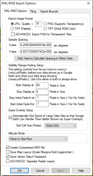
Export Image Format
The KML/KMZ Export Options panel allows
the user to set up the target image format for storage and the sample
spacing, as well as other options such as whether to store all of the
resulting files in a KMZ file (recommended) and whether or not to render
and save loaded vector data.
Selecting the ADVANCED: Export PNG for Transparent Tiles option use transparent PNG images for any exports with transparent pixels when the JPG format is chosen for the export. This allows you to use the best compressed JPG images whenever possible and only switching to PNG for transparency when absolutely necessary.
Sample Spacing
The Sample Spacing section allows the user to select the grid spacing to use when generating the file. The default value is the average of the grid spacings of all the currently loaded raster and elevation overlays.
If the Always Generate Square Pixels option is checked, the smaller of the specified x and y resolutions will be used for both the x and y resolution.
Selecting Always Generate Square Pixels ensures that the resultant image file will look good even in software that is not able to deal with pixels that aren't square.
To specify the spacing in units other than those of the currently selected view/ export projection, press the Click Here to Calculate Spacing in Other Units button.
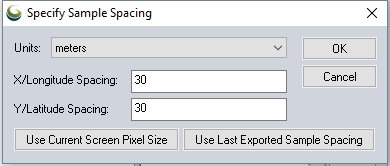
Specify the X and Y spacing of the output pixels in any of the selected units. These pixel dimensions will be translated into the units of the display projection during export. The Use Current Screen Pixel Size button will update the X and Y values to the dimensions of the map display. Use Last Exported Sample Spacing will update the X and Y values to the most recent export resolution.
Visibility Range/ Fading Setup
The Visibility Range/Fading Setup section allows advanced users to control the minLodPixels, maxLodPixels, minFadeExtent, and maxFadeExtent values used in the exported file to control when (i.e. what zoom level) the data will be displayed and also if and how to fade the data.
Super Overlay Setup
There is also an option to automatically tile the data on export (this creates what is known as a SuperOverlay). Enabling this option allows very large quantities of data to be efficiently viewed using Google Earth. When using this option you can also control the tile size to use when creating the super overlays. For very large exports the larger sizes (1024x1024 or 2048x2048) are recommended.
Altitude Mode
Clamp To Ground - Indicates to drape the overlay over the terrain.
Clamp To Sea Floor - The overlay will be draped over the sea floor. If the point is on land rather than at sea, the overlay will be positioned on the ground.
Additional Options
Create Compressed KMZ
Check this option to create a compressed kmz file instead of a kml.
Save Map Layout
Check this option to included displayed map layout elements, like scalebar, legend and map grid in the exported image file.
Save Vector Data if Displayed
Check this option to included the vector features in the output image file.
ADVANCED: Separate Raster Layers
Check this option to create multiple layers of images from the enabled data.
Tiling Panel
Export Bounds
Format Updates
Below is a summary of recent updates to KML/KMZ format support.
| Version | Description |
|---|---|
| 22.0 | Add an option to the KML/KMZ export to control the creation of folders for each geometry type. [Item #GM-10579] |
| 21.1 | Fixed bug in scripting command to export to KML files using the KML_TILE_SIZE and KML_GEN_INDEX_FILE parameters.[Item #GM-9881] |
| 21.0 | Fixed export of data crossing the ATM (anti-meridian) to KML/KMZ raster formats.[Item #GM-3210] |
| 18.2 | Added option in KML/KMZ raster exports to select 'Clamp to Ground' or 'Clamp to Seafloor'[Item #21723] |
| 18.0 | Now allows tiling raster KML/KMZ exports using the EXPORT_RASTER command with the KML_SUPER_OVERLAY option to multiple KML/KMZ files. [Item #18452] |
| 16.2 | Improved display speed of KML/KMZ files that reference a large number of images. |