Simulate Water Level Rise/ Flooding, accessed from the Terrain Analysis Menu, allows you to simulate the water coverage/ flooding by increasing the water level to a specified depth over either a fixed single elevation (like 0 for sea level) or from a selected area feature, like a flood plain area. For example, if some coastal area is selected, you can simulate increasing the sea level by some amount and see where the water would reach, taking into account any terrain features that prevent flow, like levees, buildings in the terrain, etc. This is a much better tool for modeling a change in sea levels than simply drawing water at a fixed height, which does things like fill Death Valley with water simply because it's below sea level, even though water couldn't reach there.
Another extremely important use of this function is to determine how a flood plain would expand when increased by some depth. Select the flood plain area feature(s) prior to selecting this command, then in the Water Rise Calculation Setup dialog (pictured below) you can choose to increase the water level by some amount from the selected areas. You can easily determine what would be covered by a 100-year flood plain plus an additional 2 feet. This works by finding all points in the loaded terrain that are upstream of the selected area feature(s) and whose entry point into the area(s) is less than the provided water level increase amount.
Another possible use for this is to determine the coverage of a lake at various water levels. You can start with an area of the lake at some water level, then model the lake coverage at different levels of increase in the level.
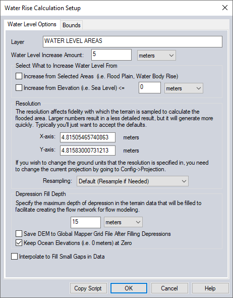
When you select the command, the dialog below appears, allowing you to setup the options for the water level rise calculation, such as the amount to raise the water level by and whether to rise from the selected areas, a fixed elevation in the terrain, or both. Internally the calculations performed are the same as for a watershed, so the depression fill and resolution settings described for the Generate Watershed command apply.
Description
Name the output layer.
Water Level Increase Amount
Specify what the flood height is, i.e. how far to raise the water level.
Select What to Increase Water Level From
Specify what constitutes the initial water level. This can be selected area features that represent water bodies, or a specific elevation.
Resolution
Specify the resolution of the analyzed grid. The resolution will default to the resolution of the loaded terrain data. Increasing this resolution will speed up processing by resampling the terrain data but will produce less detailed results. The current display projection sets the units of the cell size.
- Nearest Neighbor - simply uses the value of the sample/pixel that a sample location is in. When resampling an image this can result in a stair-step effect, but will maintain exactly the original color values of the source image.
- Bilinear Interpolation - determines the value of a new pixel based on a weighted average of the 4 pixels in the nearest 2 x 2 neighborhood of the pixel in the original image. The averaging has an anti-aliasing effect and therefore produces relatively smooth edges with less stair-step effect.
- Bicubic Interpolation - a more sophisticated method that produces smoother edges than bilinear interpolation. Here, a new pixel is a bicubic function using 16 pixels in the nearest 4 x 4 neighborhood of the pixel in the original image. This is the method most commonly used by image editing software, printer drivers, and many digital cameras for resampling images.
- Box Average (2x2, 3x3, 4x4, 5x5, 6x6, 7x7, 8x8, and 9x9) - the box average methods simply find the average values of the nearest 4 (for 2x2), 9 (for 3x3), 16 (for 4x4), 25 (for 5x5), 49 (for 7x7), 64 (for 8x8), or 81 (for 9x9) ) pixels and use that as the value of the sample location. These methods are very good for resampling data at lower resolutions. The lower the resolution of your export is as compared to the original, the larger "box" size you should use.
- Filter/Noise/Median (2x2, 3x3, 4x4, 5x5, 6x6, 7x7, 8x8, and 9x9) - the Filter/Noise/Median methods simply find the median values of the nearest 4 (for 2x2), 9 (for 3x3), 16 (for 4x4), 25 (for 5x5), 49 (for 7x7), 64 (for 8x8), or 81 (for 9x9) pixels and use that as the value of the sample location. This resampling function is useful for noisy rasters, so outlier pixels do not contribute to the kernel value. Some common sources of raster noise are previous compression artifacts or irregularities of a scanned map/image.
- Box Maximum (2x2, 3x3, 4x4, 5x5, 6x6, 7x7, 8x8, and 9x9) - the box maximum methods simply find the maximum value of the nearest 4 (for 2x2), 9 (for 3x3), 16 (for 4x4), 25 (for 5x5), 49 (for 7x7), 64 (for 8x8), or 81 (for 9x9) pixels and use that as the value of the sample location. These methods are very good for resampling elevation data at lower resolutions so that the new terrain surface has the maximum elevation value rather than the average (good for terrain avoidance). The lower the resolution of the export file is as compared to the original, the larger "box" size that should be used.
- Box Minimum (2x2, 3x3, 4x4, 5x5, 6x6, 7x7, 8x8, and 9x9) - the box minimum methods simply find the minimum value of the nearest 4 (for 2x2), 9 (for 3x3), 16 (for 4x4), 25 (for 5x5), 49 (for 7x7), 64 (for 8x8), or 81 (for 9x9) pixels and use that as the value of the sample location. These methods are very good for resampling elevation data at lower resolutions so that the new terrain surface has the minimum elevation value rather than the average. The lower the resolution of the export file is as compared to the original, the larger "box" size that should be used.
- Gaussian Blur (3x3, 5x5, 7x7) - the Gaussian blur methods calculate the value to be displayed for each pixel based on the nearest 9 (for 3x3), 25 (for 5x5), or 49 (for 7x7) pixels. The calculated value uses the Gaussian formula that weights the values based on the distance to the reference pixel.
Depression Fill Depth
Many terrain data sets will contain depressions in the data where flow would terminate unless allowed to fill the depression and spill into the surrounding terrain. The Depression Fill Depth section controls how deep of a depression will be filled before it is considered a basin and flow is allowed to terminate there. The depression fill depth value will automatically be filled in with some guess at a good value based on the range of loaded elevation values, but you might want to modify this, especially if you have relatively flat terrain with a lot of depressions. Note that it can take a while to fill particularly deep depressions. When trying to determine a good value to use for the depression fill depth, consider how high of an embankment or 'dam' the flow might encounter that you want to allow water to fill up to the top of and pour over, or also how deep of a small pond or puddle to fill and allow spilling out of. You can also check the option to Save DEM to Global Mapper Grid File After Filling Depressions to save the depression-filled terrain to a GMG file so you can load that for future watershed operations to avoid having to fill depressions again.
Interpolate to fill small gaps in data
Any small areas with missing data will be filled in by interpolating the surrounding valid data using an IDW method. This is useful for filling small gaps between adjacent tiles or small holes in elevation data.