Transform Area
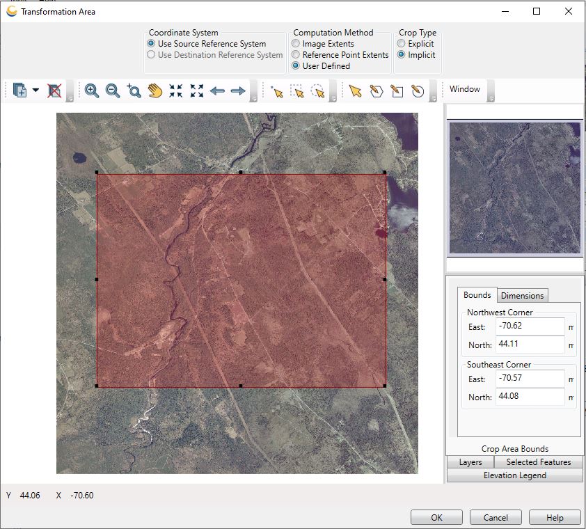
Clicking the Set Transform Area on a Raster Transform job will bring up the Transformation Area dialog:

The shaded Transformation Area will default to the image extents, but may be adjusted using the various tools and by dragging the vertices as desired. See the information on the Viewer for more details about the standard viewing tools.
The following preferences can be set for the Transformation Area:
-
Coordinate System is used to select an alternate coordinate system in which to define the crop area. This is useful when using a vector layer to define the crop region, where the vector file is the Destination Reference System.
-
Computation Method is the method by which the Crop Area is defined.
- Image Extents is the default, in which the Crop Area will extend to the entire image.
- Reference Point Extents changes the crop area to match the bounds of the control points used to tie the input image to the referencing coordinate system. TAB, GeoTIFF, and RSF referenced map images tie pixels to specific ground locations. In these cases, the correlated points do not have to be on the corners of the images.
- User Defined allows the user to define a Crop Area using the various tools in the viewing window (such as the polygon, rectangle and ellipse tools).
-
Crop Type specifies how the transformed crop area is applied. In cases where the transformed crop area is not rectangular, it will still be displayed within its minimum bounding rectangle.
-
Explicit means that only transformed points that are within the actual crop area will be displayed. Areas that are within the minimum bounding rectangle, but not within the transformed crop area itself, will be left blank and thus will display the background color.
-
Implicit means that any transformed points within the minimum bounding rectangle of the transformed crop will be displayed. Note that in the case where input image is highly pixelated this still may result in some of the background color showing.
For example, suppose the Crop Area as depicted on the input image is this red rectangle:

In an Explicit crop, the transformed crop area is a rhombus, and so the regions in pink (the background color) represent areas outside the original crop area, but inside the minimum bounding rectangle of the rhombus.

In an Implicit crop, those pink regions are displayed in the output, because they fall inside the minimum bounding rectangle of the transformed crop area.

See Non-rectangular Crops for more information on setting up non-rectangular crop areas (including cropping using boundaries defined in another vector layer) for Raster Transformation Jobs.