Performing Interactive Coordinate Conversions
To create a new Interactive Conversion job, you can:
-
Right-click in the Project Manager and select Create New Job>Jobs>Interactive Conversion
-
Go to File>New>Jobs>Interactive Conversion
-
Click on the
 button on the tool
bar.
button on the tool
bar. -
New Interactive jobs can also be created from the Start Page
Once you have your new job created:
-
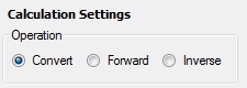
At the bottom of the Interactive job, select the Convert radio button.
-
Determine which of the two sides of the Interactive Job will be the Input side.
-
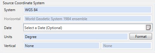
On the Input side,select the coordinate system definition that corresponds with the coordinate to be converted. The default coordinate reference system from General Preferences is pre-selected by default.
-
Use the Format button to select the display format for your input coordinates. This is very important for angular units.
-
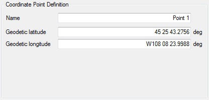
Enter the coordinate values (Latitude/Longitude, Northing/Easting or X/Y/Z) into the appropriate text boxes in the Coordinate Point area. They will be labeled according to the type of coordinate system definition you select. You may give the point a name in the Name box.
-
On the output side, select the coordinate system to which you want to convert the coordinate (Output coordinate system).
-
Use the Format button to select the display format for your output coordinates.
-
If you have selected input and output coordinate systems that are based on different Datums, you will need to select a Coordinate Transformation. If you do not, when you click the Calculate button, you will be prompted to do so.
For both Forward and Inverse conversions, when height values are entered, the distance is scaled to a height above the ellipsoid. For more information see Height Above Ellipsoid (HAE) Calculations
-
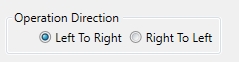
Ensure that the calculation direction button has the red arrows pointing from the input side to the output side. To change the direction of the calculation, click the button.
-
Click the Calculate button. The results of the conversion will be displayed in the Coordinate Point boxes on the output side. When converting to a projected coordinate system, Grid scale and Convergence will be included with the output. When a calculation has been completed, the coordinates will display in black.