Areas of Use
Areas of Use![]() An area of use is a polygon that defines the applicable extent of an object in the datasource, such as a coordinate reference system or transformation.They are defined as both a polygon and a minimum bounding rectangle in Latitude / Longitude coordinates in WGS84. are linked to Coordinate Systems and Coordinate Transformations, and help to define an area of acceptable usage for a coordinate system and/ or a coordinate transformation. In addition to any Custom Areas of Use
set up by Blue Marble Geographic and/ or the user, there are also the standard Area
of Use Definitions from the EPSG contained within the Datasource.
An area of use is a polygon that defines the applicable extent of an object in the datasource, such as a coordinate reference system or transformation.They are defined as both a polygon and a minimum bounding rectangle in Latitude / Longitude coordinates in WGS84. are linked to Coordinate Systems and Coordinate Transformations, and help to define an area of acceptable usage for a coordinate system and/ or a coordinate transformation. In addition to any Custom Areas of Use
set up by Blue Marble Geographic and/ or the user, there are also the standard Area
of Use Definitions from the EPSG contained within the Datasource.
You can control whether both of these types of Areas of Use are applied to jobs via the checkboxes in the Area of Use group of the Administrative Settings Filtering tab.
When areas of use filtering is active, the results seen in the datasource viewer (such as when selecting a source or target coordinate system or a transformation) will be filtered to only display results whose areas of use contain the loaded data in the job.
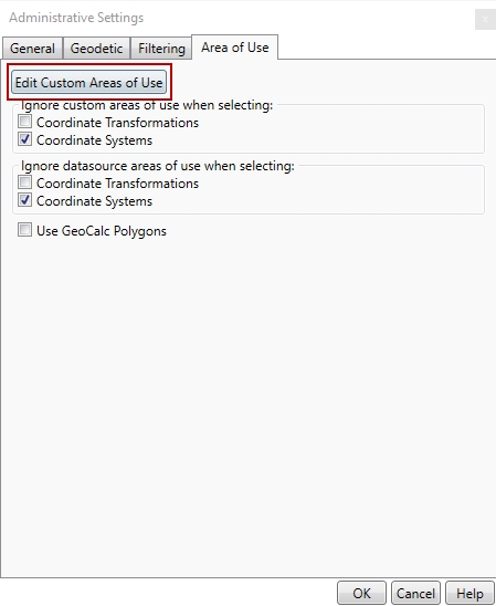
Custom areas of use are special polygons that have a specific filter of included and/ or excluded coordinate systems or transformations that may be applied for data in the area. Custom Area of Use filtering will supersede other area of use filtering. For more information see Custom Areas of Use
By default, datasource Areas of Use will be ignored when selecting Coordinate Systems, but applied to Coordinate Transformations.
For example, in an Interactive Job, when a set of coordinates is entered, the source and target selection will show the entire datasource. However the transformation selection will be limited by the datasource areas of use from the EPSG.
If the Coordinate Systems checkbox under Ignore datasource areas of uses when selecting is unchecked, then you will only be able to select coordinate systems that have areas of use that contain the coordinate specified in the Coordinate Point Definition fields.
The Use GeoCalc Polygons option uses the more detailed EPSG polygons when checking Area of Use, rather than the simpler Minimum Bounding Rectangles (MBRs). This means more precise area of use filtering, but it can slow down the selection on complex datasets.