Georeferencing Preferences
The Georeferencer tool includes preferences that control its functionality and viewer appearance. You may access the Georeferencing Preferences using the Options>Preferences menu item in the main application window, and then selecting the Georeferencer tab.
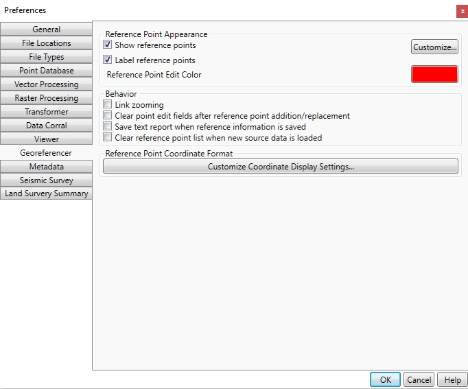
Reference Point Appearance
Clicking the Customize… button opens the Reference Point Appearance dialog, allowing customization of settings including the reference point symbol, font, sizes, and colors.
- Show Reference Points – when enabled, the reference points in the point list will be drawn in the viewer.
- Label Reference Points – when enabled, the reference point names will be displayed next to the points in the viewer.
- Reference Point Edit Color – clicking the color swatch to modify the highlight color of selected reference points on the map.
Behavior
Link Zooming – when enabled, the viewport of the source and reference viewers will be synchronized.
Clear point edit fields after reference point addition/replacement – when enabled, the Point Name, (Across) X, (Down) Y, East, and North input fields will be cleared after adding a new point or replacing an existing one.
Save text report when reference information is saved – when enabled, a .txt file containing all reference information (point list, coordinate system, solution maximum and RMSE values) will be saved along with the reference file.
Clear reference point list when new source image is loaded – when enabled, loading a new source image will clear the existing point list. When disabled, the existing point list will remain and be applied to the newly loaded image.
Reference Coordinate Format
Press Customize Coordinate Display Settings... to bring up the Unit Display Settings dialog. This setting specifies how coordinates will be displayed. There are separate sections for Geodetic Coordinates and Linear Grid Coordinates.
Geodetic Coordinates
The formats that you can select are shown below with an example (all examples represent the coordinate: South 44 degrees, 30 minutes, 15 seconds):
- Signed degrees (example: -44.50416)
- Degrees and hemisphere (example: 44.50416 S)
- Signed degrees and minutes (example: -44 30.2500)
- Degrees, minutes, and hemisphere (example: 44 30.2500 S)
- Signed degrees, minutes, and seconds (example: -44 30 15.000)
- Degrees, minutes, seconds, and hemisphere (example: 44 30 15.000 S)
Decimal Precision - specifies the number of decimal places to use with geodetic coordinates.
Linear Decimal Precision
Specify the Decimal Precision of coordinates represented in linear units.
The check box named Do not display decimal symbol on output will remove the decimal marker from your output points. This is used when output points have an implied decimal. This does not omit the decimal precision, it only omits the decimal symbol, so 1234.123 will instead display as 1234123.