Entering Points in Area Calculation
There are 3 methods to add area information to the Area Calculation job:
- Manually enter individual points
- Paste data in TAB separated format
- Load data from an external file.
Manual Entry
Individual points can be entered into the Area Polygon grid in the Settings tab of the Area Calculation job. These points will be the vertices of the polygon.
Right-click on the data area to insert rows.
Fill in the values for each vertex of the area feature. Either the Latitude Longitude or Northing and Easting values may be entered. The other information will auto-fill when pressing process.
Paste Data
You can also paste points into the Area Polygon grid from Excel.
To Paste Data in Area Calculation
The copied data must contain the column format shown in the area calculation job, but the values may be empty. This should be copied to the clipboard as tab separated data (this is the default for Excel).
To automatically check or uncheck boxes in the "Is Geodetic" column you will need to paste TRUE, for checked, or FALSE, for unchecked. For more information on column requirements see Pasting or Loading data in Area Calculation.
- Select all of the rows and columns that you wish to paste from your input data and copy them to the windows clipboard.
- Select the row below which you would like to insert the data, then right-click to Paste Data
- Click away from the selected cell to finalize your entry.
Load Data
Use the ... button at the top of the job to load in data from an external file. For more information see Opening and Saving Area Calculation Data
Edit Points
Right-click on any row to access a context menu that allows you to insert and delete rows.
Use the CTRL or SHIFT key to highlight multiple rows and then select delete or press the delete key on the keyboard to bulk remove them. This can also be used to bulk modify the Path to Next and Is Geodetic values.
See Saving Area Calculation Data for information about saving the point list.
Name
The Point Name column allows you to enter a name for each point, which is optional.
Is Geodetic
Each point can be entered either as a geodetic coordinate in the Latitude and Longitude fields, or as a projected coordinate in the Northing and Easting fields.
When the area is computed, geodetic coordinates are defined in the Base Coordinate System, and projected coordinates in the Grid Coordinate System. The Grid projected and Base geodetic coordinate systems are set under Area Calc System at the bottom of the Settings tab.
Use the CTRL or SHIFT key to highlight multiple rows, and then bulk modify this value.
Coordinates
- Projected coordinates must be entered in the units of the Grid Coordinate System.
- To use the coordinates defined by Latitude and Longitude, you must check the "Is Geodetic" box, which will cause the Calculator to compute area using the geodetic point.
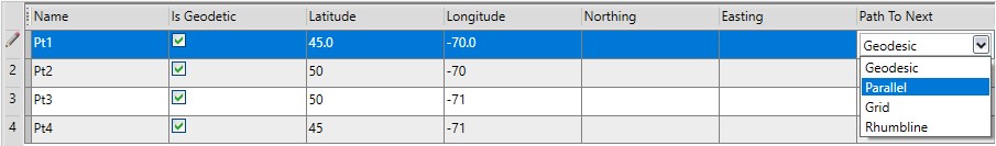
Path to Next
The Path To Next drop-down box is used to specify the type of line segment that connects the points. The value defines the line between the point defined on that row and the point defined on the next row down. These options will affect the calculated area.
- Select Geodesic to create a line that follows a geodetic (great circle) path to the next point.
- Select Parallel to create a line that follows an East-West parallel to the next point. This option can only be selected if the end points lie on the same parallel (with identical latitude).
- Select Grid to create a line of constant azimuth in the Grid Coordinate System.
- Select Rhumb to create a line of constant azimuth from the starting point to the ending point.
Use the CTRL or SHIFT keys to select multiple rows to edit. Then modify the Path to Next value of one, and all selected rows will be edited.
Note: The Area Calculation job automatically calculates a line segment from the last point entered to the first point. You do not have to enter the first point twice to close the polygon.