The Send Raster Maps to Connected Garmin Device is a very powerful option that will send any type of loaded data to a connected Garmin device for display as raster maps on the Garmin device. This is supported in Garmin GPS devices that support the display of custom raster maps. These include devices geared towards outdoor use, like the Colorado, Dakota, and Oregon series.
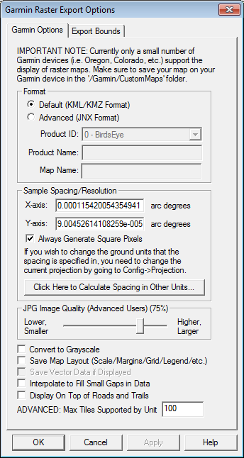
When you select the menu command, the Garmin Raster Export Options dialog (pictured below) is displayed to configure the export. Control the resolution (sample spacing) of the export, the quality setting for the JPG files that are embedded in the output files for display on the GPS device, and several other options.
You can also control the format used. The default is the Google Earth KMZ format which is official supported by Garmin, but is limited in terms of how much area you can cover with the data. The other option is the Garmin JNX format. This format allows much larger areas to be covered by using the same method that is used for the Garmin BirdsEye imagery. It can also be faster to display, than KMZ, but is more locked down. Garmin devices allow small JNX files to display without a BirdsEye subscription. Larger files may require a BirdsEye subscription from Garmin and must use Garmin's BaseCamp software to pull in the JNX from the device, then send it back to the device to unlock it.
The KMZ format maps should be saved on the device in the '/Garmin/CustomMaps' folder, while the JNX files should be saved in the 'Garmin/BirdsEye' folder. If your device is connected when you start the export the default export folder should be in the appropriate location.