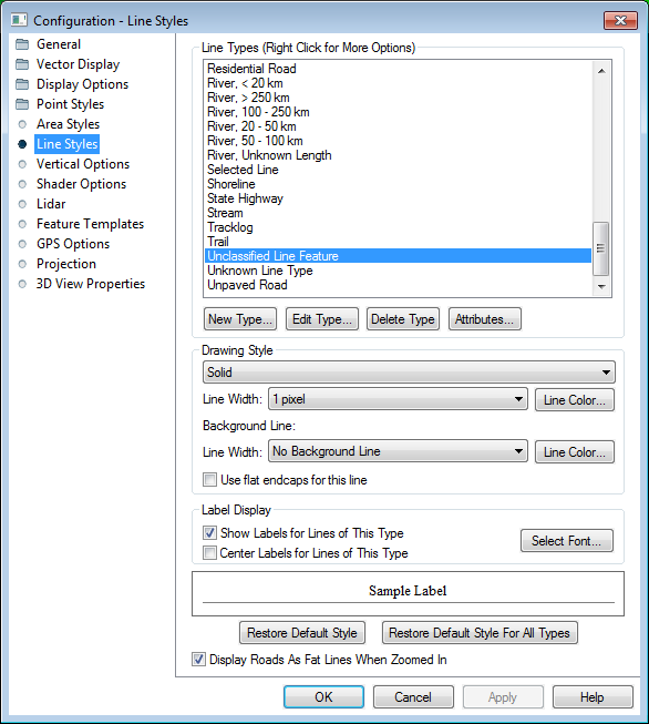
The Line Styles section of the Configuration Dialog controls the display properties for line feature types.
See Built-In Line Types and Styles for graphical reference guide to the line types and drawing styles built-in to Global Mapper.
Context Menu
Right click on the list of types, to display the menu above. This allows saving and restoring style settings using a style file. This provides an easy way to setup a set of styles to use, then restore them at a later date for use with a particular set of data.
New Types can also be loaded from cGPSMapper type files using the bottom option.
New Type...
Add a new point type and specify its symbology and labeling.
Edit Type...
Choose this option to edit name and symbol for the selected type. Built in types can not be renamed, but the symbols and labeling for the type can be modified using the sections below.
Delete Type
Delete the selected Feature Type. Custom point types are also specified in a text file in the user data folder. Built-in types can not be deleted.
Attributes...
Specify attributes that will be automatically assigned to new features created as the selected type. Default values can also be specified. For more control over possible attribute values, see Feature Templates.
The line style, width, and color can be modified on a type-by-type basis.
Line Style
See Built-In Line Types and Styles for the available line styles, or see the sample at the bottom of the dialog.
Line Width
When selecting a line width, you can choose a fixed width in screen pixels, which means that the line will draw the same width regardless of your zoom level, or you can choose the option to specify the line width as a New Fixed Width in Meters. When you do that your line will be drawn at a given number of meters in width, which means it will get thicker as you zoom in and smaller as you zoom out to maintain the same width in ground units.
Background Line
Specify a background line of a larger wish to create cased lines.
Use Flat Endcaps for this Line
Check this option to use rectangular endcaps to lines, rather than rounded ones. This difference is more visible with thicker line widths.
Label Display
Show Labels for Lines of This Type
Check this option to turn line labels on for the selected line type.
Center Label for Lines of This Type
Check this option to center the label within the line, rather than along the top of the line.
Select Label Font...
This opens a dialog for configuring the label properties for the Feature, including Font, background, relative position, size, and rotation.
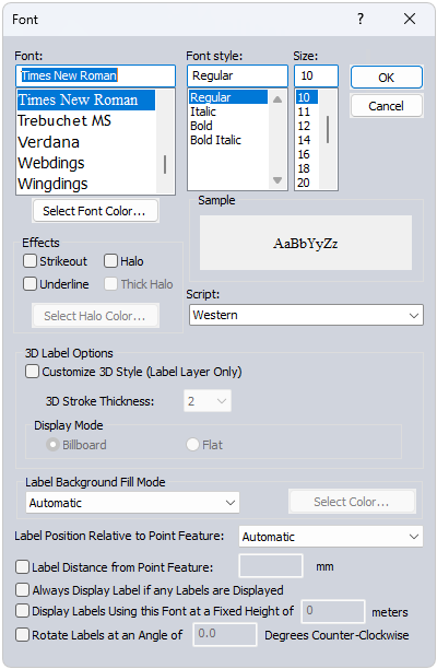
Font
Select the font to use for the label. The list will populate with available system fonts. See also Labels Configuration for default font face and character set.
Effects
Specify text effects, including a halo around the text, a specific font color, or strikeout and underline effects.
Script
Specify the script to use for the label. The available options are dependent on the selected font.
Label Background Fill Mode
Specify how to fill the background for the labels. This setting is overridden by a halo effect.
- Automatic: In most cases this will use a transparent background to the label text
- Opaque - Background Color : Label text box will use the specified background color of the workspace.
- Transparent: No text box fill color for the label.
- Opaque- Custom Color: Use the select color... button to select a custom background text box fill color.
Label Position Relative to Point Feature
Specify how the label is placed relative to the point anchor. The Automatic setting will relocate labels with movement and zoom in order to declutter and reduce label overlap.
Always Display Label if any Labels are Displayed
Objects with this label setting checked will maintain priority during label decluttering.
Display Labels using this Font at a Fixed Height in Meters
Use this setting to specify labels in a size relative to a ground unit size, rather than a font size. The labels will shrink and grow when zooming, to always maintain the same geographic scale. This setting can be particularly useful for reference features, such as labels of background area boundaries.
Rotate Labels
Specify the angle to rotate the labels.
This button will restore the default style for the selected Point Type.
This option will restore the default styles for all Point Types.
This option allows users to turn on/ off the "fattening" of road lines when zoomed in tight on them.