Info Tips are small windows that pop up when
you allow the mouse cursor to hover over data layers on the map. Info
Tips can contain the current cursor location and information about features
at the cursor location.
The Configure Info Tips command allows you to specify the information to be included in each Info Tip. To start or stop display of Info Tips, use the Enable Info Tips command in the View menu. Global Mapper will remember the Info Tip settings when you close the program.
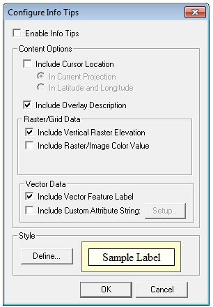
Use the Configure
Info Tips dialog (shown above) to specify the kind of information
that you would like displayed in the Info Tips. Select
Enable Info Tips to specify that Info Tips should be displayed
when the mouse cursor hovers over map layers. This has the same effect as
the Enable Info Tips command in the View menu.
Select Include Cursor Location
to indicate that you want Info Tips to contain the map coordinates under
the mouse cursor. Choose In Current Projection to display the coordinates
in the current map projection, or In Latitude and Longitude to display
them in geodetic coordinates.
Select Include Overlay Description to display the description of the layer associated with the data.
Select Include Vertical Raster Elevation to include the elevation data from the topmost vertical raster layer.
Select Include Raster/Image Color Value to have Info Tips contain the color value from the topmost raster imagery layer.
Select Include Vector Feature Label to put the label from the feature nearest to the cursor. To specify an attribute to be used for the layer, open the Overlay Control Center and click the Options... button for the vector layer.
Select Include Custom Attribute String to include custom data in Info Tips. When selected, the Setup... button will be enabled. When the Setup... button is clicked, the Setup Custom Attribute String dialog will be displayed. The user can enter the new Info Tip text, and include attribute names by enclosing the name in a pair of percent signs (example, %STATE_NAME%).
Use Define... to change the visual style elements for Info Tips. The current style is shown in the sample label in the Style group. The Select Area Style dialog will be displayed so you can choose the background color, font, and other style elements.